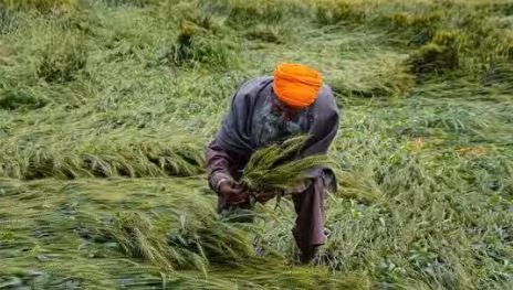
India Meteorological Department asked farmers to defer harvesting crops in Punjab, Haryana, Rajasthan, and Arunachal Pradesh
Fresh thunderstorms and hailstorm activity expected in northwest and central India until the weekend is likely to impact the harvesting of wheat and other crops, India Meteorological Department (IMD) has warned.
A western disturbance set to impact the Himalayan region was presently over Iran. It was expected to move eastwards towards north India. A cyclonic circulation was also over Rajasthan. A trough was running from Rayalaseema to Jharkhand.
Under the influence of these features, fresh rainfall, and thunderstorm are likely in northwest India until the weekend. Hailstorm is likely in Jammu, Himachal Pradesh, Uttarakhand, Punjab, Haryana, West Uttar Pradesh, Rajasthan on Friday and Uttarakhand on Saturday, IMD said. Hailstorm is also likely in central India especially Chhattisgarh, Madhya Pradesh, and Vidarbha over the weekend.
IMD said the maximum impact of thunderstorm/lightning/gusty winds and hailstorms is likely in Jammu, Himachal Pradesh, Uttarakhand, Punjab, Haryana, western Uttar Pradesh, north Rajasthan on Friday and Uttarakhand, Madhya Pradesh, Vidarbha, Chhattisgarh, Telangana on Saturday.
It said strong wind/hail may damage plantations, horticulture, and standing crops.
IMD asked farmers to defer harvesting crops in Punjab, Haryana, Rajasthan, and Arunachal Pradesh. “…keep already harvested produce in a safe place or cover the heaps of already harvested produce in the field with tarpaulin sheets…”
IMD advised deferring of sowing of jute in West Bengal and maize in Sikkim and Arunachal Pradesh. “…drain out excess water from fields; provide mechanical support to horticultural crops and use hail nets to protect orchards.”
Skymet Weather vice president (climate change and meteorology) Mahesh Palawat said there is a western disturbance and an induced cyclonic circulation over central Pakistan and west Rajasthan. “There is wind discontinuity over the peninsular region which will bring hailstorms and thundershowers to east Madhya Pradesh, Chhattisgarh, coastal Andhra Pradesh, and Telangana. On Friday and Saturday, we can expect thunderstorms and hail activity over the northern regions particularly west and north Rajasthan.”
The first spell of thunderstorms and hailstorms began on March 16. Meteorologists said heat in February and March leading to the warm land surface and the onset of pre-monsoon activity are linked. This is not very unusual even as pre-monsoon activities have started relatively early.
IMD director general M Mohapatra said convective clouds develop when there is heating. “In February, temperatures were over 5 to 6 degrees above normal. The soil was very dry and hot which creates a triggering mechanism,” he said. He said two anticyclones formed over the Bay of Bengal and the Arabian Sea brought in a lot of moisture. “…other low-level cyclonic circulations and a western disturbance impacted the Western Himalayas.”
Mohapatra said upper-level westerly winds blowing at 120 km per hour and penetrating up to peninsular India were one of the main factors in widespread hailstorms. “These colder winds brought down the freezing level so it started to rain in the form of ice which is hail.’
Squally weather and rain this month damaged wheat in almost all key producer states. But the extent of losses may be known in weeks ahead, according to preliminary assessments of a panel formed in view of anticipated early-summer heatwaves.
On Monday, IMD said a cyclonic circulation was over northeast Rajasthan and an east-west trough was running from this cyclonic circulation to Nagaland in lower tropospheric levels. Another cyclonic circulation was lying over southwest Rajasthan at lower tropospheric levels. A trough/wind discontinuity was running from interior Tamil Nadu to central Chhattisgarh in lower tropospheric levels.
Former earth sciences ministry secretary M Rajeevan called these very typical pre-monsoon activities. “…these have started a little early this year but they are not unusual. There have been years in the past also when hail has destroyed crops in many states. For such activities, deep clouds need to form…for that moisture from the Bay of Bengal and the Arabian Sea is needed. Interactions with low-latitude tropical circulation are also seen. These activities can be triggered by the warm land surface.”

Leave a Reply